We have moved our Calgary and Edmonton Locations
Spatial Technologies have been busy re-locating our Calgary and Edmonton branches. Both locations have expanded show room and stock to serve you better. Come by to visit and check out our complete range of solutions. |
|
Occurring 6 April 2019, the transmitted GPS week number in the navigation message will rollover from 1023 to 0. All currently operational Leica Geosystems GNSS receivers with the latest firmware will not be affected by this rollover. For complete information, please click here. This rollover was not an un-expected event, and Leica Geosystems have accounted for it in previous firmware releases. If unsure, please contact your representative, or email our support team with your current firmware version, and we can assist you. |
|
|
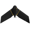
senseFly continues to lead professional UAV mapping solutions with the most complete range of cameras, including the new RedEdge-MX for the eBee X. The eBee X, with diverse camera options such as the S.O.D.A. 3D, and Duet Thermal camera, together with extended flight time of 90 min, continues to lead the industry and be the most productive UAV solution in the market.
senseFly solutions are also fully Transport Canada compliant fro Advanced RPAS Operations. Read more here. Contact Kyle for more information |
|
|
| Get ready for the Spring and Summer construction season. Leica Geosystems offers a complete range of 2D and 3D machine control solutions. The new IP67 rated MCP80 panel offers the same interface across all the different MC platforms. From mastless systems, full 3D, paving, digging and piling solutions, Leica Geosystems and Spatial Technologies can assist every aspect of your infrastructure projects. Contact our team to discuss our full service, support and installation options. |
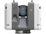
| The Fast, Agile and Precise RTC360 continues to take the HDS market by storm. Contact us to talk to a representative about bringing 2 million pts/sec and HDR images under 3 minutes to your company. |
|
The Leica iCON iCR80 construction total station, layout more points per day with ATRplus. The iCON iCR80 guarantees layout efficiency with the most reliable, simple and automatic set up procedure, industry-leading prism lock, and flexible handling of fully rendered 3D design models in the field
|
|
|
If you do not want to receive future email communication from us, please use the link: unsubscribe
Missed a newsletter? Previously issued newsletters are in our Newsletter archive on the Spatial Technologies site. Or sign up to receive these in the future. Check out our current events of webinars, seminars, and trade shows.
Spatial Technologies, 5716 Burbank Cres. SE, Calgary, AB, - T2H 1Z6 |
|
|