Catalog Updates
Thank you for your patience while we completed our new catalog. We have released so many new products, the opportunity to create the new catalog was always a moving target. But we have locked it down, and it can be downloaded here. However, since then even more products have been released, some of them are below. Contact us anytime for more information. We apologize in advance that some prices have changed since publication. |
|
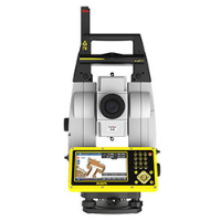
How many times have you said, 'Leica Geosystems makes the Disto, how come they don't integrate it into the total stations for height measurements!' Introducing the first total stations with integrated AutoHeight Feature. The new series of Leica Flexline can be found on our website.
|
|
|
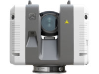
Fast
With a measuring rate of up to 2 million points per second and advanced HDR imaging system, the creation of coloured 3D point clouds can be completed in under two minutesAutomated targetless field registration |
|
Agile
Small and lightweight, the Leica RTC360 scanner's portable design compact enough to fit into most backpacks, ready to be taken anywhere.Easy-to-use, one-button operation makes for fast, hassle-free scanning. |
|
Precise
Low noise data allows for better images, resulting in crisp, high-quality scans that are rich in detail and ready for use in a range of applications. Combined with Cyclone FIELD 360 software for automated registration in the field. |
|
|
New UAV Solutions
The new eBee X with new extended 90min flight time, steep landing for constricted landing areas, ruggedized design and enhanced camera options. The new S.O.D.A 3D captures 2 oblique and 1 nadir image as it flies. Email Kyle Canning for more info. Find out more information on our Fall UAV Newsletter |
|
|
This month Leica released version 4.1 of their iCON Field Software, available in 'Build' or 'Site' versions to suit your needs.
Adding to an already impressive, intuitive suite developed primarily for efficient lay out, version 4 introduces the following enhancements:
- Compatibility with the all new iCG70T
- Capture and record images linked to your stored points
- Utilize IFC files for layout of modeled building objects
- New 'Autostaking' to lay out points on a floor or ceiling
Discover a complete list of improvements here |
|
|
Connections for Technical Support
Spatial Technologies have several channels to reach our technical support team. Through our dedicated portal there are training videos and other self help guides and a chat tool (for mobile too). Check it out |
Review our webinars/trainings/seminars and tradeshows.
Spatial Technologies events |
|
|
If you do not want to receive future email communication from us, please use the link: unsubscribe
Missed a newsletter? Previously issued newsletters are in our Newsletter archive on the Spatial Technologies site. Or sign up to receive these in the future.
Spatial Technologies, #2 21 Highfield Circle, Calgary, AB, - T2H1L9 |
|


.jpg?1540415089150)

.png?1539728812508)