There is lots of information on the internet, and then there is the benefit of talking to a subject matter expert. Kyle Canning, our UAV Manager, has years of experience in the collection of actionable data for many geomatics applications. Connect with Kyle for a discovery session of how Spatial Technologies and senseFly UAV solutions can benefit your organization.
senseFly and Parrot Business Solutions have been very active in bringing solutions to UAV mapping professionals. There is a lot to share right now, and we know you are busy so: |
|
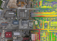
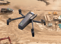
The new eBee X is a total game changer. The eBee X is the fixed-wing drone for all your mapping needs. Designed to boost the quality, efficiency and safety of your data collection, it has a camera to suit every job, the accuracy and coverage to meet every project's requirements, and can work virtually every type of site. Check out the video here |
|
|
Efficient & Precise
The eBee X can meet the exacting requirements of every project. Its unique Endurance Extension unlocks a maximum flight time of 90 min-for vast coverage of up to 500 ha (1,235 ac) at 400 ft*-while its High- Precision on Demand helps you achieve absolute accuracy of down to 3 cm (1.2 in), without GCPs. |
|
Rugged & Reliable
The eBee X allows you to work virtually every site, no matter how demanding, thanks to its space-friendly Steep Landing technology, ultra-robust design, live air traffic data and more-all backed by senseFly's trusted professional, local support. |
|
|
|
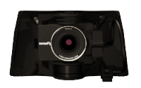
The senseFly S.O.D.A. 3D is a unique innovation-a professional drone photogrammetry camera that changes orientation during flight to capture three images (2 oblique, 1 nadir) every time, instead of just one, for a much wider field of view. It is optimised for quick, robust image processing with Pix4Dmapper. |
|
|
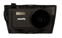
| The senseFly Aeria X is a compact drone photogrammetry powerhouse. This rugged innovation offers the perfect blend of size, weight and DSLR-like image quality. It offers stunning image detail and clarity, in virtually all light conditions, allowing you to map for more hours per day than ever before. |
|
|
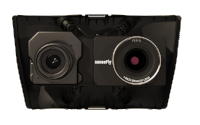
| The senseFly Duet T is a rugged dual-camera thermal mapping rig. Use it to create geo-accurate thermal maps and digital surface models quickly and easily. |
Knowing your Cost of Ownership - senseFly Always on
Providing professional UAV services means you have to be ready for any situation. senseFly 'Always On' program gives that peace of mind. The Always On program gives you that. It includes:
All warranty replacements at no cost to end user
- 2 replacements for non-warranty cases (ie bird strike), delivered at best effort in 48 hours
- Up to 6 battery swaps - always in pairs
- Up to 3 wing and 4 propeller replacement
|
| Parrot Business Solutions |
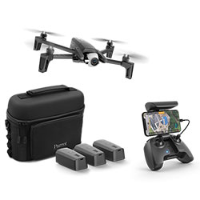
ANAFI WORK
The 4K ultra-compact drone solution for every business
- ANAFI Work is an ultra compact tool for professionals, helping them make informed decisions using the drone's aerial insights.
- ANAFI Work includes the advanced ANAFI drone equipped with an innovative imaging system, a 4K/21MP camera with a 180° vertical orientation, allowing you to easily capture images of inaccessible areas.
- ANAFI Work is the perfect on-the-go tool that is ready-to-fly in no time. The drone operates for 1 hour and 40 minutes with its 4 USB-C smart batteries.
- This Parrot drone solution can easily be transported anywhere in its compact shoulder bag.
- ANAFI Work allows professionals to create 3D models of buildings, quickly and easily, using the one year subscription to Pix4Dmodel.
|
 |
 |
If you do not want to receive future email communication from us, please use the link: unsubscribe
Missed a newsletter? Previously issued newsletters are in our Newsletter archive on the Spatial Technologies site. Or sign up to receive these in the future.
Spatial Technologies, #2 21 Highfield Circle, Calgary, AB, - T2H1L9 |
|
|


.png?1539622064858)